

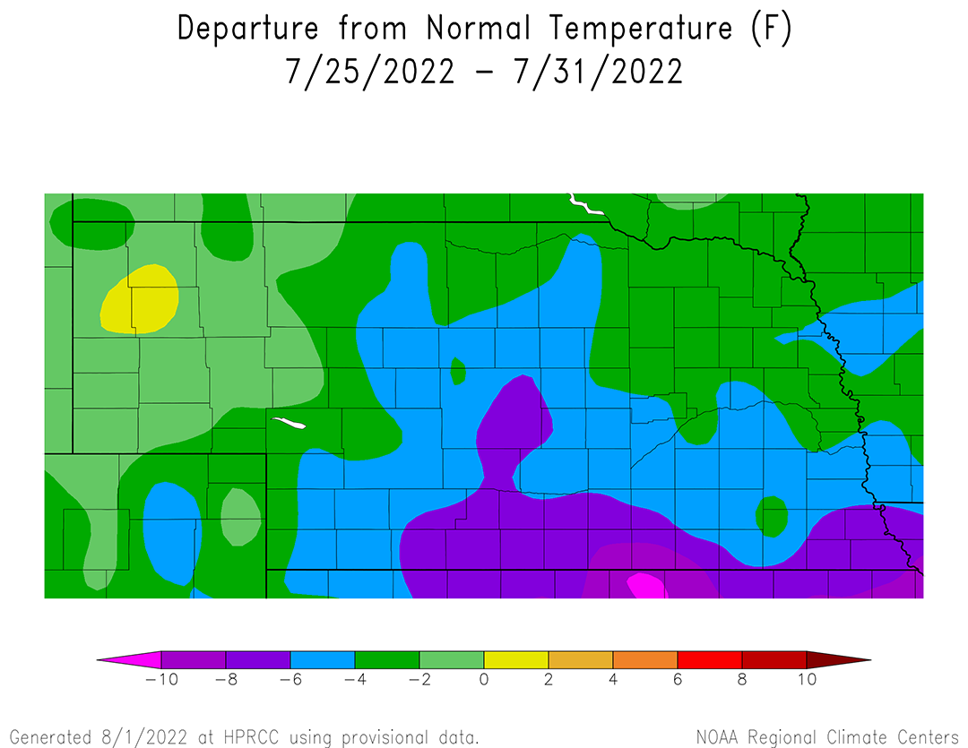
Below-normal temperatures dominated Nebraska last week as a strong upper air trough moved across the northern Plains and deepened as it reached the western Great Lakes. High temperatures were confined to the upper 70s to middle 80s during the weekday period before returning to the 90s this past weekend. Average temperatures were 4-8°F below normal south of I-80 from McCook eastward to the Iowa border, as well as pockets of central and north-central Nebraska. A small area of south-central Nebraska along the Kansas border averaged 8-10°F below normal. The vast majority of the Panhandle reported average temperatures ranging from normal to 2°F above normal, while the remainder of the state averaged 2-4°F below normal.
As the upper air trough progressed toward the Great Lakes, weak pieces of energy moving southeastward on its backside triggered a concentrated area of 1-3 inches of moisture across south-central and central Nebraska (Figure 2), but this activity weakened substantially as it progressed eastward. Figure 2 indicates widespread 0.50-1.00 inches of moisture fell across east-central, southeast, southwest and west-central Nebraska based upon cooperative observer reports. However, when examining NERain reports which have four to five times the spatial density, precipitation reports indicated that there was considerable variability and not nearly the precipitation coverage suggested by using only cooperative observer reports.
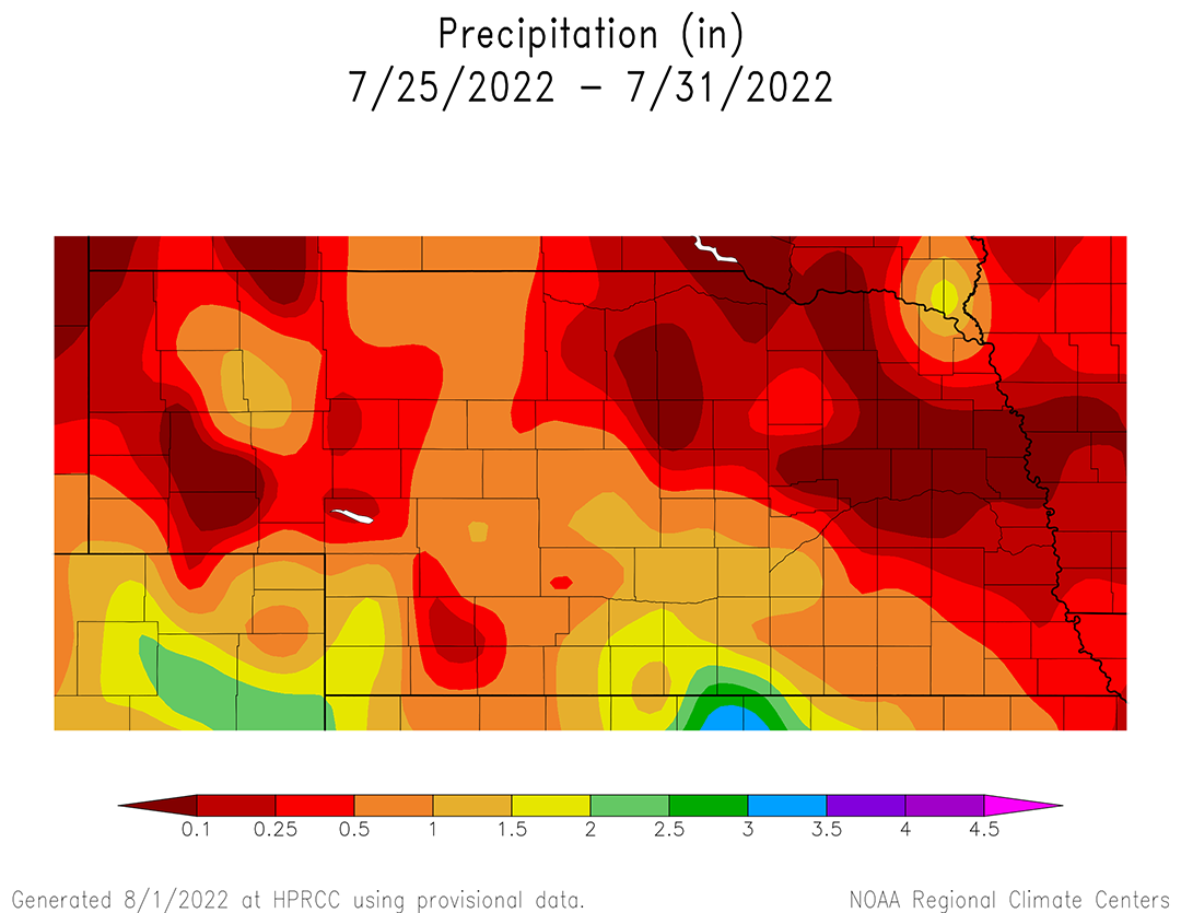
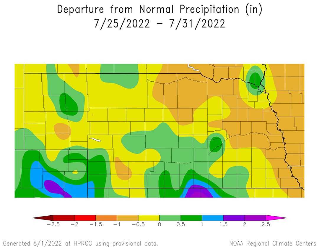
There was consistency between NERain and cooperative observer reports across the Panhandle and northeastern fourth of Nebraska where these networks indicated less than 0.25 inches of moisture was observed last week. Although Figure 3 indicates surplus moisture fell this past week wherever cumulative totals in Figure 2 exceeded one inch, surplus moisture greater than 0.50 inches was confined to small pockets of southwest, south-central, central and west-central Nebraska.
After very active weather last month, there was a large drop in severe weather reports issued by storm spotters across Nebraska during the month of July. The Storm Prediction Center’s (SPC) preliminary storm report database shows that 36 hail and 113 wind reports were submitted by storm spotters during July, which compares to 292 hail and 196 wind reports submitted in June. The sharp reduction in severe weather reports during July coincides with a northward expansion of the southern Plains upper air ridge and a reduction in precipitation activity associated with upper air lows crossing the northern half of the High Plains region. Even though there were distinct periods of above- and below-normal temperatures during July, the cumulative impacts resulted in above-normal temperatures for the northwestern two-thirds of Nebraska (Figure 4).
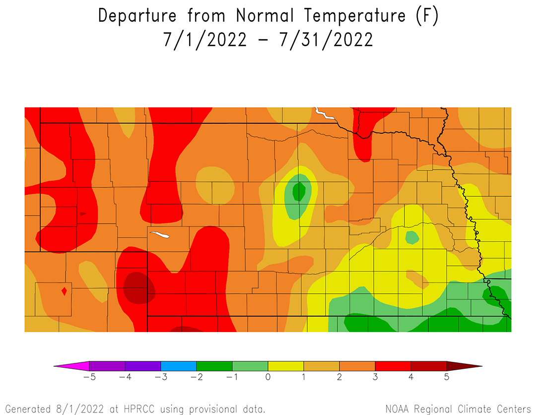
Average temperatures were 2-3°F below normal across the western half of state, except for pockets of the Panhandle, southwest and west-central Nebraska where anomalies increased to 3-5°F above normal. Across the eastern half of Nebraska, July average temperature anomalies ranged from 2-3°F above normal across the northeast, normal to 2°F above normal across east-central and the northern half of southeast Nebraska. Average temperature anomalies were normal to 1°F below normal along the Kansas border from Red Cloud to the Iowa border.
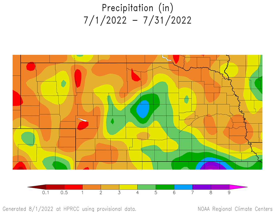
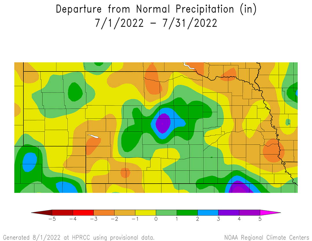
Precipitation totals for the month of July were less than two inches for most of western third of the state, along with parts of northeast and east-central Nebraska (Figure 5). Monthly precipitation totals ranged from three to seven inches from the southern half of the Sandhill region south-southeast through south-central Nebraska, then eastward along the Kansas border to the Missouri river. There were two pockets of six- to seven-inch precipitation totals reported in July, northern Custer County and the southern third of Jefferson County. Essentially, any location receiving more than three inches of moisture during the month was in an area depicted with moisture surpluses (Figure 6). Precipitation anomalies were 1-2 inches below normal during July across large areas of east-central, northeast, north-central and southwest Nebraska. It is these areas of the state that are currently most susceptible to further drought degradation during the first half of August, if the forecast for above-normal temperatures and below-normal precipitation verifies.
Crop Progress
Although average temperatures were cooler than normal this past week across Nebraska, the lack of widespread precipitation led to further deterioration in regard to pasture and rangeland conditions, warm-season crop health and soil moisture, according to the Nebraska Agricultural Statistics Service (NASS). There has been a steady decline during July in regard to these variables and further degradation is likely considering that short-term models indicate above-normal temperatures are favored over the next two weeks. Longer term, the Climate Prediction Center indicates that odds are tilted toward dry and warm conditions for the month of August and for the August through October period, which includes the start of the fall harvest period.
Even through above-normal moisture was observed from south-central Nebraska northward into the southern Sandhills, the vast majority of area outside of this region struggled to receive more than a quarter inch of moisture. Subsequently, statewide topsoil and subsoil conditions deteriorated for a third consecutive week. NASS reports that topsoil moisture as of Aug. 1 is rated 31% very short, 39% short, 30% adequate and 0% surplus. Subsoil moisture is rated 30% very short, 39% short, 31% adequate and 0% surplus. Topsoil rated very short to short increased to 70% this week compared to 68% last week. However, very short conditions increased five percentage points, compared to a decrease of three percentage points in the short category. Subsoil rated very short to short increased three percentage points to 69%, which was the result of a three-percentage decline in subsoil moisture rated adequate.
NASS reports that the condition of the corn crop as of July 31 was estimated at 10% very poor, 12% poor, 25% fair, 40% good and 13% excellent. The poor and very poor categories increased four percentage points from the prior week and each individual categories increased two percentage points. The crop was estimated to be 84% silked, compared to 95% last year and the five-year average of 90%. Corn in the dough stage was estimated at 21%, compared to 37% last year and the five-year average of 30%. Corn development will likely continue to lag last year and the five-year average for the remainder of the season due to the widespread replanting that occurred due to extensive hail damage during the first half of June.
The condition of the soybean crop also deteriorated over the past week, although at a slightly slower pace than corn. As of July 31, NASS estimates the condition of the soybean crop at 6% very poor, 11% poor, 26% fair 28% good and 8% excellent. There was a four-percentage point increase for soybeans rated poor to very poor from the previous week, while the good category decrease three percentage points and a one percentage point decrease in the air category. NASS estimates that 85% of the soybeans are blooming, compared to 94% last year and the five-year average of 87%. Soybeans setting pods was estimated to be 50%, which compares to 64% last year and the five-year average of 54%.
The dryness issues across southwestern Nebraska continues to impact the health of the state sorghum crop. NASS currently rates the crop as 8% very poor, 25% poor, 31% fair, 28% good and 8% excellent. Compared to conditions on July 24, sorghum rated poor to very poor expanded six percentage points, while sorghum rated fair or good both declined three percentage points. Sorghum is estimated to be 32% headed, which compares to 45% last year, as well as the five-year average.
Weather Outlook
It appears that above-normal temperatures and below-normal moisture will be the dominate story for the first 10 days of the upcoming forecast according to the latest GFS model run issued the morning of Aug. 2. There is more uncertainty in regard to precipitation the second 10 days of the month as a strong monsoon moisture feed from the southwest desert region may interact with an upper air trough predicted to move across the northern Plains. Although the GFS model doesn’t currently depict widespread moisture for Nebraska under this scenario, it does indicate that chances for moisture exist than what is currently depicted to occur the middle of next week.
In the short term (Aug. 2-12), the GFS model keeps the upper air ridge in place through Aug. 4 before an upper air trough is forecast to cross the northern Plains and flatten the top of this ridge temporarily Aug. 5-7. Maximum temperatures are forecast to cool from the mid-90s to low 100s Aug. 2-4, into the upper 80s to the middle 90s Aug. 5-8.
The GFS model is showing a weak signal for isolated thunderstorms during the evening of Aug. 2 through the morning of Aug. 3 (Panhandle, northeast) and the evenings of Aug. 5-7 (Panhandle, southwest). If the GFS model is correct in its forecast depiction, precipitation will not be widespread or of sufficient quantity to improve drought conditions across the state. Most locations will likely remain precipitation-free, which would intensify drought conditions in the short term.
The upper ridge is forecast to build back into the central United States by Aug. 9, which is expected to bring a return of upper 90s to low 100°F high temperatures through Aug. 13, before another upper air trough is forecast to move across the northern Plains. High temperatures are forecast to cool back into the upper 80s to the middle 90s. At the same time, the GFS model also increases precipitation chances across western Nebraska Aug. 14-15 due to monsoon moisture being transported northward and interacting with the upper air trough. This moisture is forecast to spread eastward Aug. 16-17, increasing chances for scattered thunderstorm activity statewide. These moisture chances are not currently depicted as being widespread but do indicate that a possible break from our current heat event may be trying to develop entering the second half of August.


